
Round the Corner World
Devon- UK, Europe, US, and beyond –
From Prawle Point to Gammon Head – Devon UK

We were a little group of 3 doing this walk together and had planned to go on a coastal walk for a while, so all keen to make it happen. It turned out to be a very windy day, Sunday early afternoon and we had brought our picnic to share hoping to get a good view of the sea and cliffs.
During the night there were gale force winds and in the morning the wind had subsided a bit, while it was raining on and off. It was difficult to decide whether to walk or not, because the weather down here can change so much from location to location. And sure enough we set off from Totnes when it had just started to rain and arrived to a blue sky at the National Trust Car park outside East Prawle leading down to Prawle Point.
I had not been on this walk before – what struck me was the drama of the coastline with its steep and rugged edges of rocks and grass covered borders where we were walking in cosy company with the local sheep grazing there and a few other walkers.


Just as you enter the fields to join the coastal path there are some Second World War bunkers covered in grass. During the war the fields were host to a radar station and in the bunkers was where the transmitters and receivers were kept.
- If you stand on the bunker roof and look towards the east, you can see the features of a raised beach in the cliffs which was formed during the Ice Age by falling sea levels.
As we began to walk on the coastal path west towards Gammon Head I wanted to have a look at the coast guard station off Prawle Point and managed to make it to the little building close to the cliff edge. The views from there were stunning, but I didn’t stay there for long because the wind was so strong I could barely stand upright, so I decided to go back to the path and come back another time to see the tiny visitor centre that is also based there.


- Prawle Point – was once a site of a medieval chapel. This was back in 1204 where it was know as Prahuille, meaning ‘a look-out hill’.
- It is the furthest south point of Devon and has been home to a coastguard station on and off since the 1860s.
The sea views on the path towards Elender Cove and Gammon Head is now dominating the landscape and you can see Bolt Head across the bay leading into Salcombe – the way the grass, sea and cliffs merge into each other in this view is breath taking.


On the path to Elender Cove you will come across old standing stones, also generally called orthostats, because they are standing upright, rather than lying down – which formed stone walls in ancient field systems. They are protected as ‘Scheduled Monuments’ and could be thousands of years old.
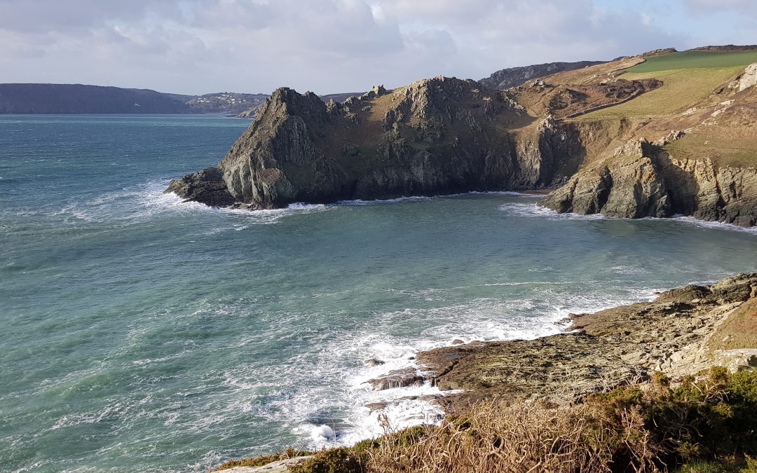
You then turn a corner to the right and there in front is Elender Cove and views across to Gammon Head.
The path here is a bit steep and narrow and I saw sheep grazing on the grassy side of the cliffs, dangerously close to the steep cliff edge. I was wondering how they managed to stay safe and wondered how many sheep were lost to the sea every year. Maybe some or maybe none, I hope the latter, but maybe somebody knows.


We sat down for our picnic very close to Elender Cove, enjoying the view of the every changing formation of the waves going in and out down below us. It was almost meditative to watch. Sometimes the waves seem to go in opposite direction, one going out while another was coming in, and the way the wind played with the top of the waves was also mesmerising to watch. We had to hold on to everything, from hats to bags, to picnic wrapping, or it would fly away – and we had found a relatively sheltered spot.
Moving on from our picnic spot and having passed Elender Cove there is another cove, Maceley Cove, much smaller, far down, that you can now get a glimpse of.

Here is Maceley Cove seen from the top of the landscape.

If the tide is out it reveals a hidden beach, but the path down to it is steep and it was not really a day for exploring whether access to this beach was safe or not. Yet it was fascinating to look down at the drama of the waves hitting the rocks and sand in the small cove.
The strong wind and noisy sea added to the drama that day. The coastal walk itself was probably 2.5 km and you could walk it in about an hour or much faster than we did, but because there was so much to explore and with the picnic as well, it took us at least 3 hours to walk from Prawle Point to Gammon Head along the coastal route. From there we turned right and headed back via a shortcut along the fields further inland and were back at the car park before we knew it.
It was really good to feel the wind on your face, we don’t do this often enough – felt so inspired afterwards. Had a hot cup of chocolate when we got back and I was buzzing from all the impressions 🙂


Make a Video Tour
Coastal walk from Prawle Point to Gammon Head – Devon, UK – Part 1
0 Comments